[ Free educational experience · Albay, Bicol, Philippines ]
Mayon Volcano — Beneath the Perfect Cone
Discover the landscape, history, and hidden workings of Mayon Volcano in Bicol, Philippines. Explore an interactive 3D experience, investigate the evidence beneath the surface, and follow the next chapter of the Mayon Volcano app.
Open the experience
Browser
Version 1.5 — available now
The full experience runs in a browser on a phone, tablet or computer. No install and no account.
Open in your browser ↗Android
On Google Play
The Play listing reported version 1.4 when this page was last checked, so the 1.5 additions below may not have reached it yet.
Open the Android listing ↗iPhone and iPad
On the App Store
The App Store listing does not publish a version we can read automatically. Check the listing for what it currently offers.
Open the iPhone and iPad listing ↗Version 1.5 is live in the browser. Store listings are checked by hand, so treat the version each store offers as whatever that store says today.
[ Meet Mayon ]
A mountain people live with, not beside
Mayon rises from the plain of Albay province in the Bicol Region of Luzon, with Legazpi City at its southern foot and farmland, barangays and the ruins of the old Cagsawa church around its base. It is the most active volcano in the Philippines: the record of its eruptions is long, and living within sight of it means living with evacuation routes, permanent danger zones and agricultural seasons shaped by the mountain.
Its shape is the reason people recognise it from a photograph. A stratovolcano built by many eruptions of similar material from one central vent accumulates layers at similar angles all the way round, and Mayon has been rebuilt often enough that erosion never gets far. The cone is the record of that repetition.
- Where
- Albay, Bicol Region
- On Luzon in the Philippines, rising directly behind Legazpi and the towns around its base.
- Smithsonian Global Volcanism Program ↗
- Type
- Stratovolcano
- Built from repeated eruptions of similar lava and fragmental material, which is what produces the steep, near-symmetrical cone.
- Smithsonian Global Volcanism Program ↗
- Height
- About 2,462–2,463 m
- Published figures differ slightly and change with eruptions and re-surveys; the app renders its terrain against 2,463 m. Treat either number as a reference, not a measurement made here.
- Smithsonian Global Volcanism Program ↗
- Current activity
- PHIVOLCS publishes it
- This page and the app never show an alert level. PHIVOLCS is the authority for current status, warnings and instructions.
- PHIVOLCS volcano portal ↗
[ Safety boundary ]
Neither this page nor the app is a monitoring, alert, forecast, evacuation or navigation service, and neither displays a current alert level. For Mayon's current condition and what to do about it, read PHIVOLCS ↗ and follow local authorities.
[ Inside the app ]
What you actually do in it
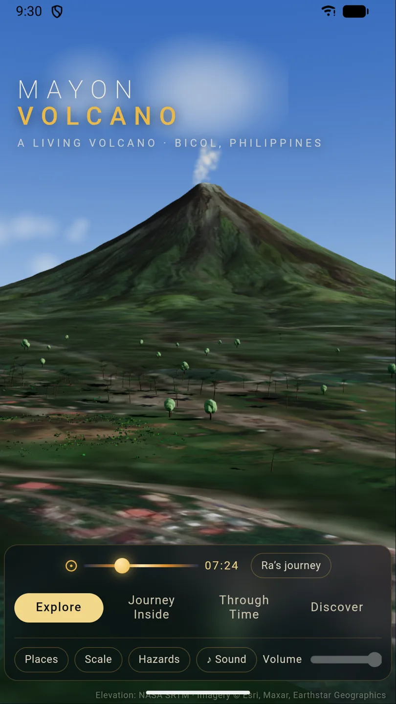
Four ways in: Explore the surface, Journey Inside the conceptual interior, move Through Time across two centuries of eruptions, and Discover the guides, evidence register and teacher pack. These are frames from version 1.5, captured on 16 September 2026.
Explore: the cone at true scale
Turn the mountain, move the sun through the day, and switch on places, scale comparisons or hazard scenarios. Terrain is NASA SRTM elevation under an Esri imagery drape.
Open this in the browser ↗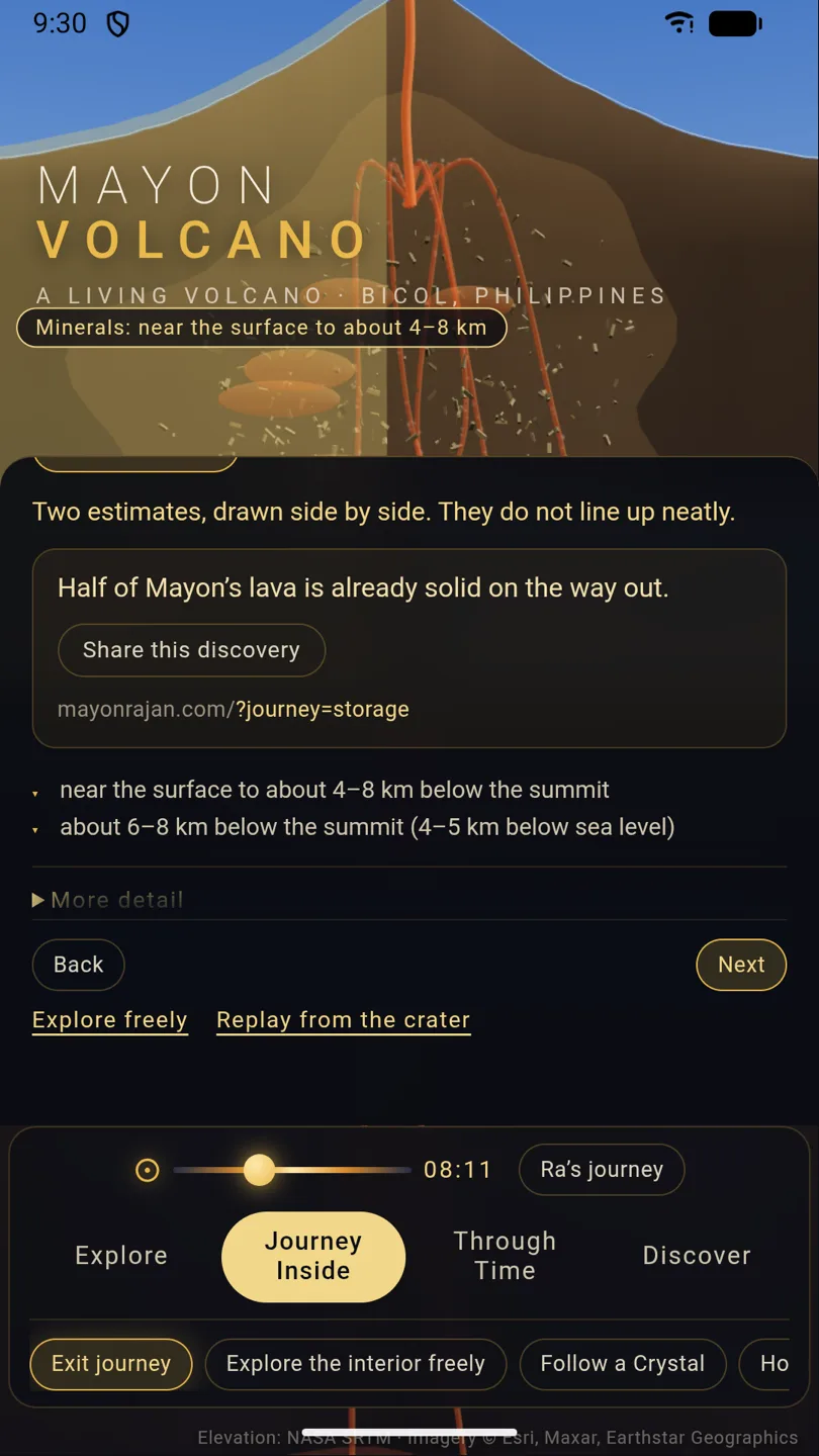
Journey Inside: the storage station
Descend through four stations beneath the summit. Each one draws what is proposed, not photographed, and the panel keeps competing depth estimates side by side instead of choosing one.
Open this in the browser ↗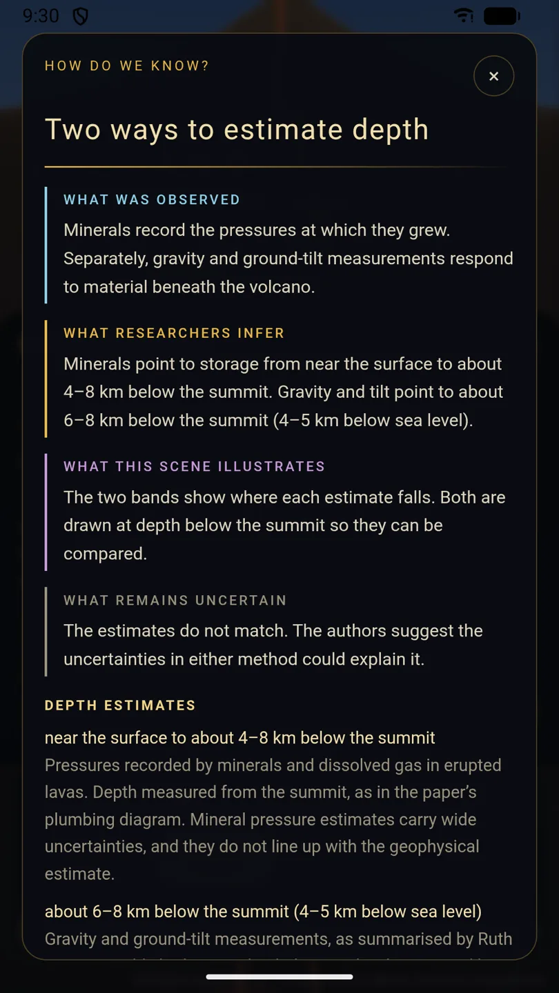
How do we know?
Every station opens an evidence panel split four ways: observed, inferred, illustrated, uncertain. Here it shows two published depth estimates that do not agree, and says so.
Open this in the browser ↗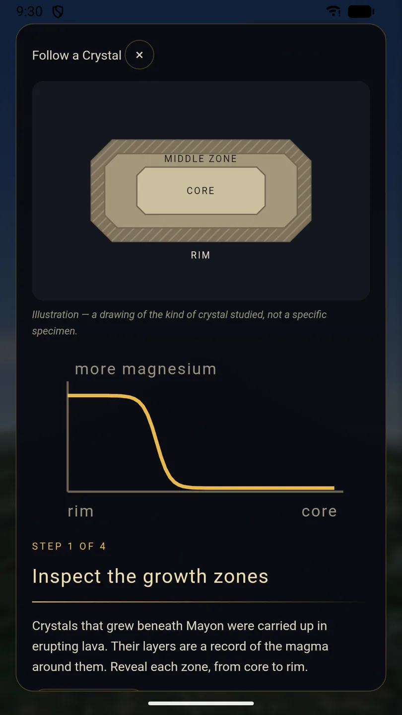
Follow a Crystal
Reveal a crystal zone at a time and read the magnesium profile across it. The drawing is labelled as the kind of crystal studied, not a particular specimen.
Open this in the browser ↗
[ Version 1.5 · live in the browser ]
Beneath the Perfect Cone
Journey Inside
A guided descent through four stations beneath the summit, from the vent to a crystal-rich region roughly 18–20 km down. The geometry is a conceptual model informed by published research, not a scan of the interior.
Start at the storage station ↗Follow a Crystal
Reveal a crystal's growth zones one at a time and read the magnesium profile from core to rim — the reasoning volcanologists use to argue that new magma arrived before an eruption.
Open the investigation ↗How do we know?
Each station opens a panel that separates what was observed, what researchers infer, what the scene illustrates, and what remains uncertain — including two depth estimates that disagree.
See it at the deep station ↗Prefer to read it? Beneath the Perfect Cone ↗ is the written companion to the descent, and the public change log ↗ records what changed in each release.
[ Understand the mountain ]
Six questions, answered
Where is Mayon Volcano?
Mayon stands in Albay province, in the Bicol Region of south-eastern Luzon, Philippines. Legazpi City sits at its southern foot, and farmland, barangays and the ruins at Cagsawa ring its base. It is the most active volcano in the country, and the communities around it live with that continuously rather than occasionally.
Why is its cone so recognisable?
Mayon is a stratovolcano: it has been built up by many eruptions of broadly similar material from a central vent. Lava, ash and fragmental debris settle at similar angles on every side, so the profile stays steep and close to symmetrical instead of spreading into a broad dome or collapsing into a caldera. Erosion between eruptions has not had long enough to break that shape up.
What might be beneath the surface?
Nobody has seen it. Researchers infer the plumbing from what erupted material records and from how the ground responds at the surface. A 2021 study in the Bulletin of Volcanology set two approaches beside each other at Mayon: pressures recorded by minerals and dissolved gas suggest storage from near the surface to roughly 4–8 km below the summit, while gravity and ground-tilt measurements point to about 6–8 km below the summit, which is 4–5 km below sea level. The two do not line up, and the authors treat the uncertainties in each method as the likely explanation. The app draws both bands rather than picking one.
How do crystals help scientists study magma?
Crystals grow in layers, and each layer forms under the conditions around it at the time. When an eruption carries them to the surface, those layers survive as a record: a change in composition from core to rim marks a change in the magma. In the app you reveal the zones one at a time and read the magnesium profile across a crystal, which is the same reasoning volcanologists use to argue that fresh magma arrived before an eruption. The crystal drawn on screen represents the kind of crystal studied, not one specific specimen.
What does the app show, and what is illustrative?
The terrain is real elevation data with a satellite imagery drape. The eruption history follows the documented record. The interior is not observed: chambers, conduits and depth bands are a conceptual model informed by published research, and the app labels them that way at each station through its How do we know? panels, which separate what was observed, what researchers infer, what the scene illustrates and what remains uncertain. Hazard scenes are teaching overlays, never forecasts.
Can I explore it without installing an app?
Yes. The complete experience, including the 1.5 additions, runs in a browser at mayonrajan.com with no install and no account. The Android and iOS listings exist for people who prefer an app on their device, and their store pages state what version each currently offers.
The app's own library goes further: methods and limits ↗, the source and evidence register ↗, and the project background on this site.
[ Version 2.0 · a proposal ]
The Living Mountain
This is a concept film. Its imagery is generated artwork illustrating experiences we would like to build. It is not a recording of the app, and nothing in it is available today.
One minute, no sound required to follow it. Watch on YouTube instead ↗
Where this could go
Available
Journey Inside, Follow a Crystal, evidence panels
Shipped in 1.5 and live in the browser now.
Exploring
Deeper interior investigations
More stations, more of the reasoning behind each depth estimate, and investigations that let a visitor test an interpretation rather than read it.
Exploring
Volcanoes as planetary systems
Connecting one mountain to volcanism elsewhere: what a cone, a crystal and a gas measurement say about a planet that is still cooling.
Exploring
Community perspectives on Mayon as home
Memory, language and daily life around the mountain, contributed and credited by the people they belong to. Nothing is collected yet.
No dates are promised, and nothing here is a paid feature. The Volcanic Engine ↗ is optional reading: a working paper on volcanism and planetary systems, not peer reviewed, and not a validation of this model of Mayon.
[ Mayon as home ]
If you live with this mountain, we would rather learn from you than guess
A terrain model and a set of papers can describe a volcano. They cannot describe what it is like to grow up under one: which view means home, what the older generation remembers, which words in Bikol carry meanings that a translation flattens, what a farmer watches for that no instrument reports.
We would like to hear from residents of Albay and the wider Bicol Region, teachers, local historians, researchers, artists and cultural organisations — about everyday memory, local knowledge, language, history, and how people relate to the mountain.
How this would work
- Nothing is used without asking. Any contribution is used only with your specific permission, with presentation and credit agreed first.
- We do not lift posts, photographs, usernames or stories from anywhere else and present them as testimonials.
- There is no partnership, commission or funded programme behind this — it is an open invitation, and we cannot promise a reply time.
Email reaches mayone@mahastrategies.com. It is not an emergency channel; for current volcanic activity, use PHIVOLCS.
[ For educators ]
Take the mountain into a classroom
The app's teacher hub holds a ready-made route through a 20–45 minute lesson, student prompts, a QR poster for a projector or corridor wall, and slides. It is free, needs no account, and runs on whatever browser the room already has.
Open the teacher hub ↗What is reviewed, and what is not
The terrain, imagery and eruption-history sources are listed claim by claim in the app's evidence register ↗. Parts of the wider learning library are explicitly an unreviewed seed curriculum, and say so on the page.
Nothing here is endorsed by PHIVOLCS or approved against a national curriculum. Use it as a teaching aid, and treat the hazard scenes as discussion material rather than official guidance.
[ Sources and corrections ]
Where this comes from
- PHIVOLCS — Philippine Institute of Volcanology and Seismology ↗
The authority for current activity, alert levels and public instructions. Nothing on this page is a substitute for it.
- Smithsonian Global Volcanism Program — Mayon ↗
Reference record for Mayon’s location, volcano type, summit elevation and eruption history.
- Bulletin of Volcanology (2021) — petrological constraints at Mayon ↗
The published work behind the two depth estimates described above. It constrains the plumbing; it does not image the shapes the app draws.
- Mayon Volcano Natural Park — UNESCO tentative list ↗
The park is on the Philippines’ tentative list. A tentative listing is a proposal for future consideration, not World Heritage inscription.
- Mayon app source and evidence register ↗
Claim-level record of what each source in the app is used for, including terrain and imagery providers, with the date each was last checked.
The project
Mayon Volcano is published by Maha Strategies LLC and built by Mayone Maha Rajan. The interactive lives at mayonrajan.com; this page is its home on the company site.
Corrections
If something here is wrong — a fact, a source, an accessibility problem, or a caption that misdescribes what the app does — write to mayone@mahastrategies.com and it will be fixed or removed.
Facts, statuses and links on this page last checked 2026-09-16.
Looking for Māyōṉ in early Tamil literature? That is a different subject that happens to share a spelling. Read the source-bound Māyōṉ dossier. It has no historical, geographic or religious connection to the volcano.